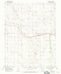
1968 Map of Chivington
USGS Topo · Published 1971About this map
Chivington sits as the central settlement on this High Plains landscape, a community defined by the long arc of the Missouri Pacific railroad. The rails traverse the territory alongside Rush Creek, which cuts through the undulating terrain toward its eventual confluence with Big Sandy Creek in the southeast. This geography reflects the late 1960s rail-and-ranching economy of Kiowa County, where small-scale industrial markers like the Gravel Pit and public spaces such as the Roadside Park provide specific landmarks for local history researchers. Genealogists will find particular value in the location of the France Cem, situated north of the main rail line. The sparse distribution of features underscores the isolation of these eastern Colorado prairie settlements during this era of agricultural transition.
Find a feature on this map
9 named features on this map. Tap any name to fly to it.
Don’t see what you’re looking for? This feature index may not catch every label — zoom into the map to look around manually.
Map Details
Editions of this 1968 Chivington Map
This is the sole edition of this map. No revisions or reprints were ever made.
Other maps of this area

1890 · Granada
USGS Topo · 1:125,000

1891 · Kit Carson
USGS Topo · 1:125,000

1892 · Lamar
USGS Topo · 1:125,000

1892 · Cheyenne Wells
USGS Topo · 1:125,000

1892 · Granada
USGS Topo · 1:125,000

1893 · Kit Carson
USGS Topo · 1:125,000

1894 · Cheyenne Wells
USGS Topo · 1:125,000

1894 · Granada
USGS Topo · 1:125,000

1954 · Lamar
USGS Topo · 1:250,000

1958 · Lamar
USGS Topo · 1:250,000