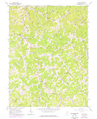
1966 Map of Chloe
USGS Topo · Published 1976About this map
Little Kanawha River and the West Fork Little Kanawha River define the winding drainage patterns of this Central West Virginia landscape during the mid-1960s. The region is characterized by a dense network of small rural settlements and religious centers, including Orma, Minnora, and Chloe, which are connected by narrow roads following the creek beds. Cultural markers such as Ebenezer Ch, Prudence Chapel, and Beech Grove Ch are scattered across the hillsides, serving the remote hollows. The map reveals an extensive system of energy infrastructure, with numerous gas wells and cross-country pipelines traversing the terrain of Washington and Birch districts. Local education is represented by the Minnora Sch and Walker Sch, while community landmarks like Roadside Park near Little Kanawha River provide a glimpse into the local geography and social fabric of Calhoun County.
Find a feature on this map
57 named features on this map. Tap any name to fly to it.
Don’t see what you’re looking for? This feature index may not catch every label — zoom into the map to look around manually.
Map Details
Editions of this 1966 Chloe Map
2 editions found
Other maps of this area

1893 · Sutton
USGS Topo · 1:125,000

1906 · Glenville
USGS Topo · 1:62,500

1906 · Otter
USGS Topo · 1:62,500

1907 · Otter
USGS Topo · 1:62,500

1907 · Arnoldsburg
USGS Topo · 1:62,500

1908 · Gassaway
USGS Topo · 1:48,000

1910 · Gassaway
USGS Topo · 1:62,500

1925 · Glenville
USGS Topo · 1:62,500

1925 · Arnoldsburg
USGS Topo · 1:62,500

1927 · Arnoldsburg
USGS Topo · 1:62,500