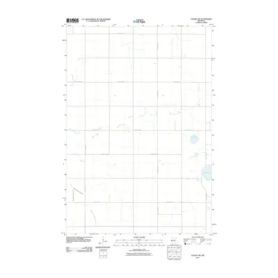
2010 Map of Chokio NW
USGS Topo · Published 2010About this map
Twelvemile Creek and its tributary, the East Fork Twelvemile Creek, meander across this agricultural landscape in Stevens County. The terrain is defined by a strictly rectilinear grid of rural routes, including County Hwy-13 and County Hwy-17, which facilitate movement through the open prairie. Several water bodies interrupt the farm plots, most notably Mud Lake and Fish Lake in the eastern portion of the quadrangle. The presence of County Ditch Number Fifteen underscores the importance of water management and drainage in maintaining the productivity of this fertile region. While primarily rural, the dense network of numbered county highways demonstrates a highly organized infrastructure connecting the dispersed farmsteads of the early twenty-first century.
Find a feature on this map
14 named features on this map. Tap any name to fly to it.
Don’t see what you’re looking for? This feature index may not catch every label — zoom into the map to look around manually.
Map Details
Editions of this 2010 Chokio NW Map
This is the sole edition of this map. No revisions or reprints were ever made.
Other maps of this area

1910 · Chokio
USGS Topo · 1:62,500

1911 · Herman
USGS Topo · 1:62,500

1912 · Chokio
USGS Topo · 1:62,500

1950 · Graceville
USGS Topo · 1:62,500

1951 · Wheaton
USGS Topo · 1:62,500

1953 · Milbank
USGS Topo · 1:250,000

1958 · Milbank
USGS Topo · 1:250,000
1973 · Alberta
USGS Topo · 1:24,000
1973 · Herman
USGS Topo · 1:24,000
1973 · Donnelly
USGS Topo · 1:24,000