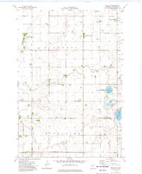
1973 Map of Chokio NW
USGS Topo · Published 1975About this map
Twelvemile Creek winds through the agricultural landscape of Stevens County, defining the drainage patterns of Eldorado and Everglade townships in the early 1970s. This prairie environment is characterized by a high concentration of conservation lands and managed wetlands, reflecting a mid-century commitment to habitat preservation. Significant protected areas such as the Everglade State Wildlife Management Area and the National Waterfowl Production Area surround Mud Lake and Fish Lake, indicating the region's importance for migratory birds. The map also captures the practical modifications of the era, including County Ditch No 15 and various Gravel Pits, which speak to the infrastructure and industrial needs of the rural community.
Find a feature on this map
14 named features on this map. Tap any name to fly to it.
Don’t see what you’re looking for? This feature index may not catch every label — zoom into the map to look around manually.
Map Details
Editions of this 1973 Chokio NW Map
This is the sole edition of this map. No revisions or reprints were ever made.
Other maps of this area

1910 · Chokio
USGS Topo · 1:62,500

1911 · Herman
USGS Topo · 1:62,500

1912 · Chokio
USGS Topo · 1:62,500

1950 · Graceville
USGS Topo · 1:62,500

1951 · Wheaton
USGS Topo · 1:62,500

1953 · Milbank
USGS Topo · 1:250,000

1958 · Milbank
USGS Topo · 1:250,000
1973 · Alberta
USGS Topo · 1:24,000
1973 · Herman
USGS Topo · 1:24,000
1973 · Donnelly
USGS Topo · 1:24,000