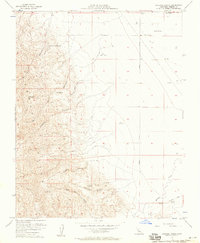
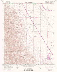
1956 Map of Chounet Ranch
USGS Topo · Published 1957About this map
The arid foothills and alluvial plains of western Fresno County are defined here by a series of steep drainages including Gres Canyon, Capita Canyon, and Dosados Canyon. In the mid-1950s, this landscape was primarily utilized for large-scale ranching operations, centered on the Chounet Ranch and Wood Ranch in the north. The rugged western terrain is punctuated by high points such as Nonada Hill and the survey station VABM Pandone, while the lower eastern half shows the early irrigation infrastructure of the Chaney Ranch Can. A single Prospect in the hills suggests early mineral exploration, while the layout of Russell Avenue and Panoche Road establishes the transportation framework connecting these remote ranch lands to the wider San Joaquin Valley.
Find a feature on this map
18 named features on this map. Tap any name to fly to it.
Don’t see what you’re looking for? This feature index may not catch every label — zoom into the map to look around manually.
Map Details
Editions of this 1956 Chounet Ranch Map
5 editions found
Other maps of this area

1913 · Panoche
USGS Topo · 1:125,000

1921 · Laguna Seca Ranch
USGS Topo · 1:31,680

1921 · Tierra Loma School
USGS Topo · 1:31,680

1922 · Chaney Ranch
USGS Topo · 1:31,680

1923 · Laguna Seca Ranch
USGS Topo · 1:31,680

1923 · Wisdom Well
USGS Topo · 1:31,680

1923 · Tierra Loma School
USGS Topo · 1:31,680

1923 · Little Panoche
USGS Topo · 1:31,680

1923 · Monocline Ridge
USGS Topo · 1:31,680

1943 · Ortigalita Peak
USGS Topo · 1:62,500