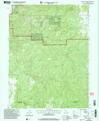
2001 Map of Chriss Canyon
USGS Topo · Published 2004About this map
The Sanpitch Mountains dominate this high-elevation landscape along the border of Juab and Sanpete counties. As a snapshot from the turn of the millennium, the map shows the Uinta National Forest as it was administered by the Manti-La Sal National Forest, highlighting a complex network of canyons and drainage systems. Water sources are critical here, with named features like Cold Spring, Spring (Alkali), and Chriss Creek carving through the terrain.
Find a feature on this map
34 named features on this map. Tap any name to fly to it.
Don’t see what you’re looking for? This feature index may not catch every label — zoom into the map to look around manually.
Map Details
Editions of this 2001 Chriss Canyon Map
This is the sole edition of this map. No revisions or reprints were ever made.
Other maps of this area

1885 · Manti
USGS Topo · 1:250,000

1895 · Manti
USGS Topo · 1:250,000

1951 · Moroni
USGS Topo · 1:62,500

1951 · Nephi
USGS Topo · 1:62,500

1956 · Price
USGS Topo · 1:250,000

1960 · Price
USGS Topo · 1:250,000

1962 · Price
USGS Topo · 1:250,000
1965 · Hells Kitchen Canyon SW
USGS Topo · 1:24,000

1965 · Chriss Canyon
USGS Topo · 1:24,000

1965 · Hells Kitchen Canyon SE
USGS Topo · 1:24,000