
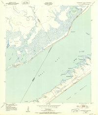
1943 Map of Christmas Point
USGS Topo · Published 1958About this map
Follets Island and the protective barrier of Mud Island define this coastal stretch of the Texas Gulf, mapped during the mid-1940s by the Army Map Service. The landscape is dominated by the intricate hydrological connections of Christmas Bay, Bastrop Bay, and Drum Bay, all linked by the prominent Intracoastal Waterway cutting through the marshlands. Notable landmarks like Christmas Point and Rattlesnake Point mark the transition between open water and the low-lying terrain of Bastrop Bayou. Local history researchers can trace the natural shoreline before later development, identifying specific features such as Titum Tuttum Bayou, Arcadia Reef, and Cedar Cut. The map captures the quiet, pre-modern state of the coast, where only a few light-duty roads provided access to the water's edge, and San Luis Pass served as the primary opening to the Gulf of Mexico.
Find a feature on this map
35 named features on this map. Tap any name to fly to it.
Don’t see what you’re looking for? This feature index may not catch every label — zoom into the map to look around manually.
Map Details
Editions of this 1943 Christmas Point Map
This is the sole edition of this map. No revisions or reprints were ever made.
Other maps of this area

1929 · Karankawa Lake
USGS Topo · 1:24,000

1933 · Karankawa Lake
USGS Topo · 1:31,680

1933 · San Luis Pass
USGS Topo · 1:31,680

1943 · San Luis Pass
USGS Topo · 1:31,680

1943 · Oyster Creek
USGS Topo · 1:31,680

1943 · Danbury
USGS Topo · 1:31,680

1943 · Freeport
USGS Topo · 1:31,680
1943 · Carancahua Lake
USGS Topo · 1:24,000

1943 · Chocolate Bay
USGS Topo · 1:24,000

1950 · Houston
USGS Topo · 1:250,000