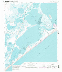
1965 Map of Christmas Point
USGS Topo · Published 1977About this map
Follets Island and the complex salt marshes of the Texas coast are depicted here during the mid-1960s, prior to significant modern development. This coastal environment is defined by the Intracoastal Waterway, which cuts through the wetlands to connect Bastrop Bay and Drum Bay. The map highlights the intersection of commerce and geography, with a Gas Well and a remote Landing Strip situated among the winding tidal channels like Titlum-Tatlum Bayou and Moodys Bayou.
Find a feature on this map
37 named features on this map. Tap any name to fly to it.
Don’t see what you’re looking for? This feature index may not catch every label — zoom into the map to look around manually.
Map Details
Editions of this 1965 Christmas Point Map
3 editions found
Other maps of this area

1929 · Karankawa Lake
USGS Topo · 1:24,000

1933 · Karankawa Lake
USGS Topo · 1:31,680

1933 · San Luis Pass
USGS Topo · 1:31,680

1943 · San Luis Pass
USGS Topo · 1:31,680

1943 · Oyster Creek
USGS Topo · 1:31,680

1943 · Danbury
USGS Topo · 1:31,680

1943 · Freeport
USGS Topo · 1:31,680
1943 · Carancahua Lake
USGS Topo · 1:24,000

1943 · Christmas Point
USGS Topo · 1:24,000

1943 · Chocolate Bay
USGS Topo · 1:24,000