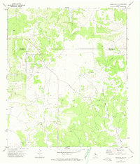
1972 Map of Christoval SE
USGS Topo · Published 1974About this map
Schleicher County ranchlands and energy infrastructure define this 1970s landscape along the border of Tom Green Co Schleicher Co. The industrial footprint of the O'Harrow Oil Field is prominent in the southwest, marked by a dense network of oil wells, pumping stations, and a radio tower. This energy activity contrasts with the natural drainage of the Edwards Plateau, where the headwaters of Pecan Creek, Kickapoo Creek, and Dry Creek carve through the terrain. Human transit is centered on Rudd Road, which serves as a primary artery through a landscape dotted with numerous gravel pits and exploratory drill holes. The map captures a specific era of West Texas land use, balancing traditional ranching acreage like the Field with the expanding reach of petroleum extraction and associated pipelines.
Find a feature on this map
17 named features on this map. Tap any name to fly to it.
Don’t see what you’re looking for? This feature index may not catch every label — zoom into the map to look around manually.
Map Details
Editions of this 1972 Christoval SE Map
This is the sole edition of this map. No revisions or reprints were ever made.
Other maps of this area

1892 · San Angelo
USGS Topo · 1:125,000

1893 · Fort McKavett
USGS Topo · 1:125,000

1954 · Sonora
USGS Topo · 1:250,000

1954 · San Angelo
USGS Topo · 1:250,000

1958 · Sonora
USGS Topo · 1:250,000

1958 · San Angelo
USGS Topo · 1:250,000

1963 · Adams
USGS Topo · 1:24,000

1963 · Adams NW
USGS Topo · 1:24,000

1965 · San Angelo
USGS Topo · 1:250,000

1970 · Rocking Chair Ranch
USGS Topo · 1:24,000