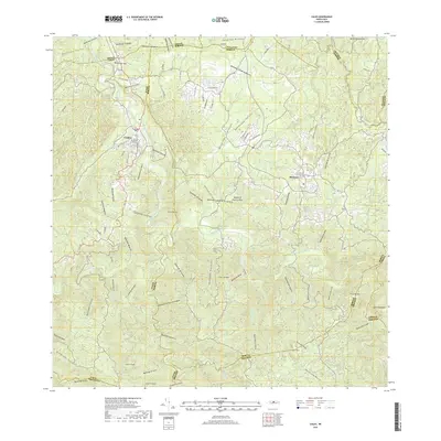
2018 Map of Ciales
USGS Topo · Published 2018About this map
The town of Ciales sits as a central hub on the north-central slopes of the Island of Puerto Rico, where the landscape is defined by the deep carving of the Río Grande de Manatí and its numerous tributaries. This survey captures the intricate relationship between human settlement and the complex hydrography of the region, where roads like PR 149 must navigate between steep elevations and winding stream beds. To the east, the municipality of Morovis is anchored among the hills, while the southern reaches of the quadrangle rise toward significant peaks such as Cerro Avispa and Cerro Cedro. Genealogists and local historians will find the Cementerio de Ciales clearly marked near the town center. The map documents a rugged interior geography where nearly every valley is named, from Quebrada Ventana to Quebrada del Pozo de Magala, illustrating a deeply established rural naming tradition that persists alongside modern infrastructure.
Find a feature on this map
75 named features on this map. Tap any name to fly to it.
Don’t see what you’re looking for? This feature index may not catch every label — zoom into the map to look around manually.
Map Details
Editions of this 2018 Ciales Map
This is the sole edition of this map. No revisions or reprints were ever made.
Other maps of this area

1940 · Vega Alta
USGS Topo · 1:30,000

1942 · Manati
USGS Topo · 1:30,000

1942 · Barceloneta
USGS Topo · 1:30,000

1946 · Corozal
USGS Topo · 1:30,000

1946 · Barranquitas
USGS Topo · 1:30,000

1946 · Barceloneta
USGS Topo · 1:30,000

1946 · Ciales
USGS Topo · 1:30,000

1946 · Jayuya
USGS Topo · 1:30,000

1946 · Florida
USGS Topo · 1:30,000

1946 · Vega Alta
USGS Topo · 1:30,000