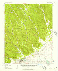
1955 Map of Cimarron
USGS Topo · Published 1957About this map
Cimarron sits at the foot of the Sangre de Cristo Mountains, where the high plains meet a series of deep, branching canyons. This mid-1950s survey detail reveals a transition from the ranching and agricultural lands of the W S Ranch and French Lake to the complex terrain of the Beaubien and Miranda Grant (Maxwell Grant). The landscape is defined by its drainage patterns, with the Vermejo River and Cimarron Creek carving paths through the foothills. A notable piece of industrial history is visible at Dawson, where the Old Railroad Grade and the Lauretta Mine mark the legacy of coal mining in the region. The map also traces established paths like the Vermejo Trail and Burns Trail, providing a clear view of how land use and transportation once relied on these natural corridors before the modern development of northern New Mexico.
Find a feature on this map
43 named features on this map. Tap any name to fly to it.
Don’t see what you’re looking for? This feature index may not catch every label — zoom into the map to look around manually.
Map Details
Editions of this 1955 Cimarron Map
Other maps of this area

1915 · Brilliant
USGS Topo · 1:62,500

1915 · Koehler
USGS Topo · 1:62,500

1917 · Koehler
USGS Topo · 1:62,500

1954 · Raton
USGS Topo · 1:250,000

1955 · Cimarron
USGS Topo · 1:62,500

1955 · Ute Park
USGS Topo · 1:62,500

1956 · Tooth Of Time
USGS Topo · 1:62,500

1956 · Miami
USGS Topo · 1:62,500

1958 · Raton
USGS Topo · 1:250,000

1962 · Ash Mountain
USGS Topo · 1:62,500