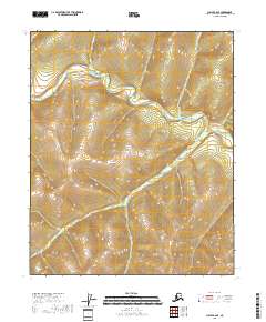
2018 Map of Circle B-2 SE
USGS Topo · Published 2018About this map
Birch Creek winds through the interior of the Yukon-Koyukuk Census Area, defining the drainage patterns of this Alaskan landscape. The waterway is joined by several tributaries, including Sheep Cr and Buckley Bar Cr, as it meanders through Township 6 North and Township 5 North. A notable landmark along the western reach is Pitkas Bar, a point of interest for those studying the historical geography of the region's stream-side terrain. The map also records the paths of Traverse Cr and Portage Cr in the northern sections, illustrating the complex network of minor creeks that feed the primary basin. This 2018 survey documents the state of these hydraulic features and their surrounding elevations, providing a clear view of the natural topography in a region where watercourses historically dictated movement and resource access.
Find a feature on this map
10 named features on this map. Tap any name to fly to it.
Don’t see what you’re looking for? This feature index may not catch every label — zoom into the map to look around manually.
Map Details
Editions of this 2018 Circle B-2 SE Map
This is the sole edition of this map. No revisions or reprints were ever made.
Other maps of this area

1951 · Circle
USGS Topo · 1:250,000

1955 · Circle A-2
USGS Topo · 1:63,360

1955 · Circle A-1
USGS Topo · 1:63,360

1955 · Circle B-1
USGS Topo · 1:63,360

1955 · Circle B-2
USGS Topo · 1:63,360

1955 · Circle
USGS Topo · 1:250,000

1964 · Circle
USGS Topo · 1:250,000
2018 · Circle B-2 NW
USGS Topo · 1:25,000
2018 · Circle A-2 NW
USGS Topo · 1:25,000
2018 · Circle A-2 NE
USGS Topo · 1:25,000