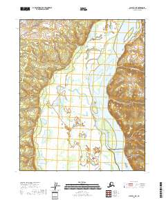
2018 Map of Circle C-1 NE
USGS Topo · Published 2018About this map
The Yukon River carves a massive, meandering path through this interior Alaska landscape, defining the topography of the Yukon-Koyukuk census area. On the eastern bank, the boundary of the Yukon-Charley Rivers National Preserve encompasses a wild stretch of river corridor and upland drainage. This 2018 survey reveals the complex hydrology of the river basin, where seasonal fluctuations and historical drainage patterns are marked by features like Ninemile Lake and the mouth of Fourteenmile Cr. The terrain is characterized by broad wetlands and floodplains that stretch across several townships, including t11n r17e, providing a clear view of the natural transition between the river's edge and the rising hills of the Alaskan interior.
Find a feature on this map
10 named features on this map. Tap any name to fly to it.
Don’t see what you’re looking for? This feature index may not catch every label — zoom into the map to look around manually.
Map Details
Editions of this 2018 Circle C-1 NE Map
This is the sole edition of this map. No revisions or reprints were ever made.
Other maps of this area

1951 · Charley River
USGS Topo · 1:250,000

1951 · Circle
USGS Topo · 1:250,000

1955 · Circle D-1
USGS Topo · 1:63,360

1955 · Circle C-1
USGS Topo · 1:63,360

1955 · Circle
USGS Topo · 1:250,000

1956 · Charley River C-6
USGS Topo · 1:63,360
1956 · Charley River D-6
USGS Topo · 1:63,360

1956 · Charley River
USGS Topo · 1:250,000

1964 · Circle
USGS Topo · 1:250,000
2018 · Circle C-1 NW
USGS Topo · 1:25,000