
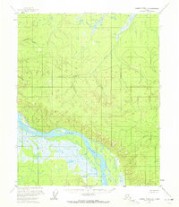
1956 Map of Charley River C-6
USGS Topo · Published 1960About this map
The Yukon River carves a massive, winding path through the southern half of this mid-century survey, surrounded by an intricate network of wetlands and high ridges. The landscape is dominated by complex topography, including a prominent summit at VABM Yukon 18 2505 and the drainage of Paddle Creek. A lone Cabin appears on the northern bank of the Yukon, suggesting the isolated, temporary dwellings used by trappers or travelers in this unpopulated subarctic region during the 1950s. The absence of roads or established towns emphasizes the wilderness character of the Fairbanks Meridian, where the river served as the primary corridor for movement through the interior.
Find a feature on this map
4 named features on this map. Tap any name to fly to it.
Don’t see what you’re looking for? This feature index may not catch every label — zoom into the map to look around manually.
Map Details
Editions of this 1956 Charley River C-6 Map
2 editions found
Other maps of this area

1951 · Charley River
USGS Topo · 1:250,000

1951 · Circle
USGS Topo · 1:250,000

1955 · Circle B-1
USGS Topo · 1:63,360

1955 · Circle D-1
USGS Topo · 1:63,360

1955 · Circle C-1
USGS Topo · 1:63,360

1955 · Circle
USGS Topo · 1:250,000
1956 · Charley River D-5
USGS Topo · 1:63,360

1956 · Charley River C-5
USGS Topo · 1:63,360

1956 · Charley River B-6
USGS Topo · 1:63,360

1956 · Charley River B-5
USGS Topo · 1:63,360