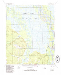
1955 Map of Circle D-1
USGS Topo · Published 1985About this map
Circle serves as a critical riverfront terminus in this interior Alaska landscape, situated where the Steese Highway meets the winding Yukon River. The topography transitions from the low-lying wetlands of the Yukon Flats to the elevated terrain of Thermokarst Bluff, illustrating the complex permafrost-shaped geography of the region. Local infrastructure is concentrated around the settlement, featuring a Landing Strip and a Cem located just south of the main hub. The hydrology of the area is dominated by the intricate meanders of Birch Creek and Big Creek, which feed into a mosaic of water bodies such as Fiasco Lake. Much of the northern portion of the map is preserved within the Yukon Flats National Wildlife Refuge, indicating the area's significance for conservation and habitat protection during the mid-20th century.
Find a feature on this map
12 named features on this map. Tap any name to fly to it.
Don’t see what you’re looking for? This feature index may not catch every label — zoom into the map to look around manually.
Map Details
Editions of this 1955 Circle D-1 Map
3 editions found
Other maps of this area

1951 · Fort Yukon
USGS Topo · 1:250,000

1951 · Charley River
USGS Topo · 1:250,000

1951 · Black River
USGS Topo · 1:250,000

1951 · Circle
USGS Topo · 1:250,000

1952 · Circle D-2
USGS Topo · 1:63,360

1955 · Circle C-2
USGS Topo · 1:63,360

1955 · Circle D-1
USGS Topo · 1:63,360

1955 · Circle C-1
USGS Topo · 1:63,360

1955 · Circle
USGS Topo · 1:250,000

1956 · Fort Yukon A-2
USGS Topo · 1:63,360