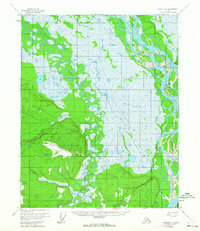
1955 Map of Circle D-1
USGS Topo · Published 1963About this map
The settlement of Circle serves as a critical terminus in this interior Alaskan landscape, situated where the Steese Highway meets the massive sweep of the Yukon River. This mid-century survey illustrates the vital connection between river navigation and overland transport, featuring a Landing Strip and a local Cem just south of the main township. The terrain is defined by the complex, meandering path of Birch Creek, which winds through vast lowlands before approaching the higher ground marked by Vabm 981 Birchy. The presence of Sixmile Creek and various triangulation stations like Vabm Bob 593 highlights the precision of the mid-1950s mapping efforts in a region where seasonal wetlands and river braids dictate the patterns of human movement and habitation.
Find a feature on this map
8 named features on this map. Tap any name to fly to it.
Don’t see what you’re looking for? This feature index may not catch every label — zoom into the map to look around manually.
Map Details
Editions of this 1955 Circle D-1 Map
3 editions found
Other maps of this area

1951 · Fort Yukon
USGS Topo · 1:250,000

1951 · Charley River
USGS Topo · 1:250,000

1951 · Black River
USGS Topo · 1:250,000

1951 · Circle
USGS Topo · 1:250,000

1952 · Circle D-2
USGS Topo · 1:63,360

1955 · Circle C-2
USGS Topo · 1:63,360

1955 · Circle D-1
USGS Topo · 1:63,360

1955 · Circle C-1
USGS Topo · 1:63,360

1955 · Circle
USGS Topo · 1:250,000

1956 · Fort Yukon A-2
USGS Topo · 1:63,360