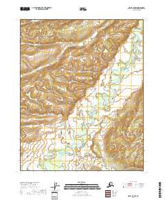
2018 Map of Circle D-5 NW
USGS Topo · Published 2018About this map
Beaver Creek provides the defining geographical structure for this interior landscape, meandering across the quadrangle in a complex series of oxbows and recursive loops. This 2018 topographic study, produced using data from the National Hydrography Dataset and National Elevation Dataset, illustrates the intricate hydrologic patterns of the Alaska interior. The map delineates several township and range boundaries, including t14n r6e, t14n r7e, t13n r6e, t13n r7e, t12n r6e, and t12n r7e, which provide the legal framework for this section of the Yukon-Koyukuk Census Area. The relief is marked by the shifting path of the creek through low-lying wetlands, captured via imagery from 2009 and later elevation surveys to show the interplay between the watercourse and its surrounding terrain.
Find a feature on this map
7 named features on this map. Tap any name to fly to it.
Don’t see what you’re looking for? This feature index may not catch every label — zoom into the map to look around manually.
Map Details
Editions of this 2018 Circle D-5 NW Map
This is the sole edition of this map. No revisions or reprints were ever made.
Other maps of this area

1951 · Fort Yukon
USGS Topo · 1:250,000

1951 · Circle
USGS Topo · 1:250,000

1951 · Circle D-6
USGS Topo · 1:63,360

1952 · Circle D-5
USGS Topo · 1:63,360

1954 · Circle D-5
USGS Topo · 1:63,360

1954 · Circle D-6
USGS Topo · 1:63,360

1955 · Circle
USGS Topo · 1:250,000
1956 · Fort Yukon A-6
USGS Topo · 1:63,360

1956 · Fort Yukon A-5
USGS Topo · 1:63,360

1956 · Fort Yukon
USGS Topo · 1:250,000