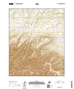
2018 Map of Circle D-6 NW
USGS Topo · Published 2018About this map
Big Cr carves a distinctive valley through this interior landscape, marking a transition between the northern lowlands and the southern upland terrain. The drainage systems, including Long Cr and E Fork Flat Cr, define the topography within the Public Land Survey System grids of t13n r4e, t14n r4e, and t12n r4e. This 2018 survey captures the unpopulated character of the Yukon-Koyukuk Census Area, where natural watercourses and elevation contours remain the primary features of the land. The mapping illustrates the complex drainage patterns and ridgelines that characterize this portion of the Circle D-6 NW quadrangle, providing essential detail for understanding the hydrological network in this region.
Find a feature on this map
9 named features on this map. Tap any name to fly to it.
Don’t see what you’re looking for? This feature index may not catch every label — zoom into the map to look around manually.
Map Details
Editions of this 2018 Circle D-6 NW Map
This is the sole edition of this map. No revisions or reprints were ever made.
Other maps of this area

1945 · Livengood
USGS Topo · 1:250,000

1951 · Fort Yukon
USGS Topo · 1:250,000

1951 · Livengood
USGS Topo · 1:250,000

1951 · Beaver
USGS Topo · 1:250,000

1951 · Circle
USGS Topo · 1:250,000

1951 · Circle D-6
USGS Topo · 1:63,360

1952 · Livengood D-1
USGS Topo · 1:63,360

1954 · Circle D-6
USGS Topo · 1:63,360
1954 · Livengood D-1
USGS Topo · 1:63,360

1955 · Circle
USGS Topo · 1:250,000