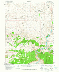
1958 Map of Cisco
USGS Topo · Published 1965About this map
The Denver and Rio Grande Western Railroad corridor dominates the northern reaches of this landscape, anchoring settlements like Cisco and White House against a backdrop of industrial activity including oil wells, gas wells, and Gravel Pits. To the south, the terrain descends into a complex network of canyons and mesas carved by the Colorado River and the Dolores River. This riverine environment supported several mid-century agricultural operations, including the Gordon Ranch, Wolverton Ranch, and Cato Ranch near the Dewey Bridge crossing.
Find a feature on this map
69 named features on this map. Tap any name to fly to it.
Don’t see what you’re looking for? This feature index may not catch every label — zoom into the map to look around manually.
Map Details
Editions of this 1958 Cisco Map
3 editions found

Other maps of this area

1885 · East Tavaputs
USGS Topo · 1:250,000

1885 · La Sal
USGS Topo · 1:250,000

1954 · Westwater 4 SW
USGS Topo · 1:24,000

1954 · Mt. Waas 4 NW
USGS Topo · 1:24,000

1954 · Mt. Waas 3 NE
USGS Topo · 1:24,000

1954 · Mt. Waas 1 SW
USGS Topo · 1:24,000

1954 · Mt. Waas 3 NW
USGS Topo · 1:24,000

1954 · Mt. Waas 1 NW
USGS Topo · 1:24,000

1954 · Coates Creek
USGS Topo · 1:62,500

1954 · Polar Mesa
USGS Topo · 1:62,500