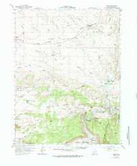
1958 Map of Cisco
USGS Topo · Published 1984About this map
The Denver and Rio Grande Western Railroad corridor dominates the high desert landscape of Grand County, where the settlement of Cisco serves as a vital infrastructure hub during the late 1950s. This survey, conducted in coordination with the United States Atomic Energy Commission, reflects an era of intense resource exploration, marked by numerous Oil and Gas Wells and the Cactus Rat Mine south of The Poison Strip. The rugged topography transitions from the high Dome Plateau and The Highlands down to the confluence of the Colorado River and Dolores River. Along the riverbanks, family-run operations like Gordon Ranch, Wolverton Ranch, and Cato Ranch occupy fertile pockets such as McGraw Bottom and Hotel Bottom. The presence of the Dewey Bridge and a nearby Gaging Station highlights the importance of river crossings and water management in this arid reach of eastern Utah.
Find a feature on this map
67 named features on this map. Tap any name to fly to it.
Don’t see what you’re looking for? This feature index may not catch every label — zoom into the map to look around manually.
Map Details
Editions of this 1958 Cisco Map
3 editions found

Other maps of this area

1885 · East Tavaputs
USGS Topo · 1:250,000

1885 · La Sal
USGS Topo · 1:250,000

1954 · Westwater 4 SW
USGS Topo · 1:24,000

1954 · Mt. Waas 4 NW
USGS Topo · 1:24,000

1954 · Mt. Waas 3 NE
USGS Topo · 1:24,000

1954 · Mt. Waas 1 SW
USGS Topo · 1:24,000

1954 · Mt. Waas 3 NW
USGS Topo · 1:24,000

1954 · Mt. Waas 1 NW
USGS Topo · 1:24,000

1954 · Coates Creek
USGS Topo · 1:62,500

1954 · Polar Mesa
USGS Topo · 1:62,500