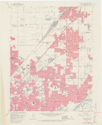
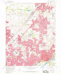
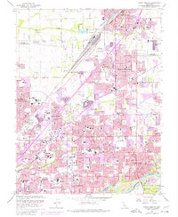
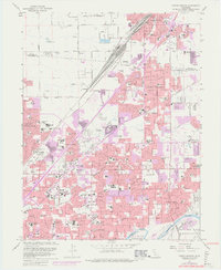
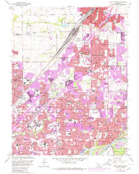
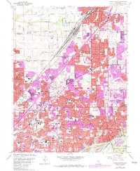
1967 Map of Citrus Heights
USGS Topo · Published 1969About this map
Suburban expansion reaches the orchards and ranches of the Sacramento Valley in this late 1960s survey. The landscape is defined by the heavy infrastructure of the Southern Pacific railroad and the residential transition of Citrus Heights and Carmichael. In the southeast, the American River (labeled here as the Rio de los Americanos) features prominent dredge tailings and a Gravel Pit near Sailor Bar, testifying to the intensive resource extraction that shaped the riverbanks. The social fabric of the era is visible through a high concentration of newly built schools like Del Campo High Sch and Bella Vista High Sch, alongside established institutions like American River College and several large memorial parks, including Mt Calvary Cemetery. Northward, the U S Mil Res and U S Military Res indicate the significant Cold War-era defense presence at the edge of North Highlands.
Find a feature on this map
105 named features on this map. Tap any name to fly to it.
Don’t see what you’re looking for? This feature index may not catch every label — zoom into the map to look around manually.
Map Details
Editions of this 1967 Citrus Heights Map
6 editions found
Other maps of this area

1891 · Sacramento
USGS Topo · 1:125,000

1892 · Sacramento
USGS Topo · 1:125,000

1893 · Sacramento
USGS Topo · 1:125,000

1902 · Fairoaks
USGS Topo · 1:62,500

1908 · Buffalo Creek
USGS Topo · 1:31,680

1910 · Roseville
USGS Topo · 1:31,680

1910 · Pleasant Grove
USGS Topo · 1:31,680

1911 · Brighton
USGS Topo · 1:31,680

1911 · Mills
USGS Topo · 1:31,680

1911 · Arcade
USGS Topo · 1:31,680