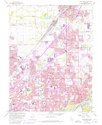
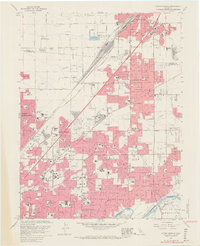
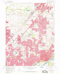
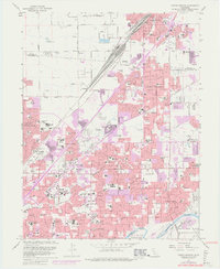
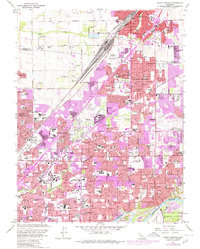
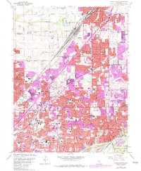
1967 Map of Citrus Heights
USGS Topo · Published 1977About this map
Citrus Heights and its neighboring communities in northeast Sacramento County show a landscape in rapid transition during the mid-twentieth century. The southern reach of the sheet follows the American River, also labeled as the Rio de los Americanos, where dredge tailings near Sailor Bar reveal the enduring physical legacy of hydraulic mining. The area is defined by its educational and religious institutions, including St John the Evangelist Sch, Kingswood Sch, and San Juan HS, alongside major healthcare facilities like Mercy San Juan Hospital. To the north, the Southern Pacific railroad corridor anchors industrial and commercial hubs near Roseville. Residential expansion is visible through numerous established neighborhoods like Foothill Farms and North Highlands, while landmarks such as the North Ridge Country Club and several large memorial parks reflect the suburbanization of former agricultural land.
Find a feature on this map
112 named features on this map. Tap any name to fly to it.
Don’t see what you’re looking for? This feature index may not catch every label — zoom into the map to look around manually.
Map Details
Editions of this 1967 Citrus Heights Map
6 editions found
Other maps of this area

1891 · Sacramento
USGS Topo · 1:125,000

1892 · Sacramento
USGS Topo · 1:125,000

1893 · Sacramento
USGS Topo · 1:125,000

1902 · Fairoaks
USGS Topo · 1:62,500

1908 · Buffalo Creek
USGS Topo · 1:31,680

1910 · Roseville
USGS Topo · 1:31,680

1910 · Pleasant Grove
USGS Topo · 1:31,680

1911 · Brighton
USGS Topo · 1:31,680

1911 · Mills
USGS Topo · 1:31,680

1911 · Arcade
USGS Topo · 1:31,680