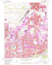
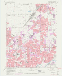
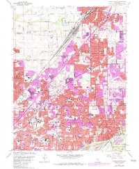
1967 Map of Citrus Heights
USGS Topo · Published 1980About this map
Roseville and Citrus Heights serve as the primary urban anchors in this Sacramento County landscape, showing the rapid expansion of mid-century residential tracts. The northern section is dominated by the Southern Pacific rail yards and the emerging healthcare infrastructure of Roseville Community Hospital. Further south, the map reveals a dense network of suburban schools like San Juan High School and American River College, catering to the post-war population boom. Along the southern edge, the American River provides a stark contrast with its Dredge Tailings and the American River Parkway, indicating the area's transition from an industrial mining past toward recreational use. This edition includes purple-shaded updates that document the accelerating conversion of orchards and open land into the modern suburbs of Foothill Farms and Carmichael.
Find a feature on this map
94 named features on this map. Tap any name to fly to it.
Don’t see what you’re looking for? This feature index may not catch every label — zoom into the map to look around manually.
Map Details
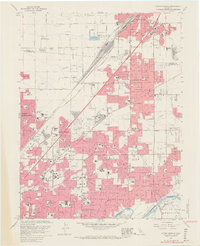
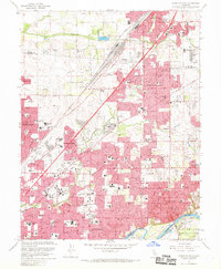
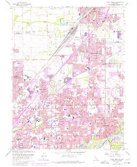
Editions of this 1967 Citrus Heights Map
6 editions found
Other maps of this area

1891 · Sacramento
USGS Topo · 1:125,000

1892 · Sacramento
USGS Topo · 1:125,000

1893 · Sacramento
USGS Topo · 1:125,000

1902 · Fairoaks
USGS Topo · 1:62,500

1908 · Buffalo Creek
USGS Topo · 1:31,680

1910 · Roseville
USGS Topo · 1:31,680

1910 · Pleasant Grove
USGS Topo · 1:31,680

1911 · Brighton
USGS Topo · 1:31,680

1911 · Mills
USGS Topo · 1:31,680

1911 · Arcade
USGS Topo · 1:31,680