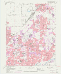
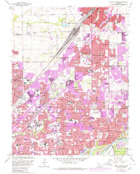
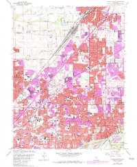
1967 Map of Citrus Heights
USGS Topo · Published 1977About this map
The Southern Pacific railroad corridor serves as the industrial and transportation backbone for Roseville as it expands southward into the suburban landscape of Sacramento County during the mid-1970s. This survey illustrates a period of rapid urbanization, with significant purple-tinted extensions of residential areas surrounding Citrus Heights and Carmichael. The map documents a dense network of educational and spiritual landmarks, from San Juan HS to the Holy Family Sch, marking the post-war growth of these communities. To the south, the American River and the Rio de los Americanos land grant define the natural boundary of Fair Oaks, where dredge tailings along the riverbank offer a stark contrast to the manicured grounds of the North Ridge Country Club. Local history is preserved in the location of several significant burial grounds, including Mt Calvary Cemetery and Sierra Hills Memorial Park.
Find a feature on this map
81 named features on this map. Tap any name to fly to it.
Don’t see what you’re looking for? This feature index may not catch every label — zoom into the map to look around manually.
Map Details
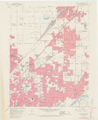
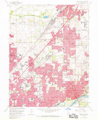
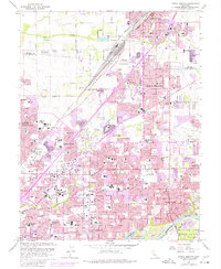
Editions of this 1967 Citrus Heights Map
6 editions found
Other maps of this area

1891 · Sacramento
USGS Topo · 1:125,000

1892 · Sacramento
USGS Topo · 1:125,000

1893 · Sacramento
USGS Topo · 1:125,000

1902 · Fairoaks
USGS Topo · 1:62,500

1908 · Buffalo Creek
USGS Topo · 1:31,680

1910 · Roseville
USGS Topo · 1:31,680

1910 · Pleasant Grove
USGS Topo · 1:31,680

1911 · Brighton
USGS Topo · 1:31,680

1911 · Mills
USGS Topo · 1:31,680

1911 · Arcade
USGS Topo · 1:31,680