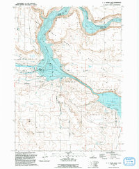
1992 Map of C.J. Strike Dam
USGS Topo · Published 1992About this map
The C J Strike Dam anchors this landscape where the Snake River and Bruneau River converge. By the early 1990s, the extensive C J Strike Reservoir and its Bruneau Arm had transformed the canyon floor into a complex of recreation and wildlife management zones, including the C J S W M A Wildlife Management Area and the Snake River Birds of Prey Area. Evidence of early westward migration persists through the Oregon Trail (South Alternate), which traverses the high ground south of the river. The small community hub around Rimrock Jr/Sr High Sch and Mormon Boulevard serves the surrounding ranching and recreation economy, while several parks like Locust Park and North Park line the reservoir's north shore.
Find a feature on this map
29 named features on this map. Tap any name to fly to it.
Don’t see what you’re looking for? This feature index may not catch every label — zoom into the map to look around manually.
Map Details
Editions of this 1992 C.J. Strike Dam Map
This is the sole edition of this map. No revisions or reprints were ever made.
Other maps of this area

1892 · Mountain Home
USGS Topo · 1:125,000

1892 · Bisuka
USGS Topo · 1:125,000

1893 · Mountain Home
USGS Topo · 1:125,000

1894 · Bisuka
USGS Topo · 1:125,000

1946 · Mouth of Bruneau
USGS Topo · 1:24,000

1947 · Little Valley
USGS Topo · 1:24,000

1947 · Grand View
USGS Topo · 1:62,500

1947 · Bruneau
USGS Topo · 1:62,500

1947 · Grand View
USGS Topo · 1:24,000

1947 · Bruneau
USGS Topo · 1:24,000