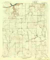
1918 Map of Clara
USGS Topo · Published 1939About this map
The Red River defines the northern boundary of this North Texas landscape, marking the border between Wichita County and Oklahoma's Tillman County during the early twentieth century. This survey reveals a rural society structured around local education and transit, with the small settlements of Clara and Stringtown serving as central points. The terrain is deeply dissected by a network of waterways including Wildhorse Creek, Gilbert Creek, and Lost Creek, which influenced the placement of homesteads and essential roads. Local education was decentralized, as evidenced by the distribution of the Fairview School, Wyeth School, and Lost Creek School. Connectivity across the plains was maintained via the Electra Road and Burkburnett Road, which connected these agricultural communities to larger nearby market towns during a period of significant regional growth.
Find a feature on this map
14 named features on this map. Tap any name to fly to it.
Don’t see what you’re looking for? This feature index may not catch every label — zoom into the map to look around manually.
Map Details
Editions of this 1918 Clara Map
2 editions found
Other maps of this area

1915 · Clara
USGS Topo · 1:24,000

1915 · Barwise School
USGS Topo · 1:24,000

1915 · Burkburnett
USGS Topo · 1:24,000

1916 · Iowa Park
USGS Topo · 1:24,000

1916 · Fowlkes
USGS Topo · 1:24,000

1918 · Buckburnett
USGS Topo · 1:31,680

1918 · Barwise School
USGS Topo · 1:31,680

1918 · Clara
USGS Topo · 1:31,680

1918 · Iowa Park
USGS Topo · 1:31,680

1919 · Fowlkes
USGS Topo · 1:31,680