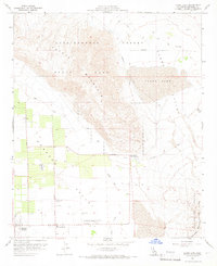
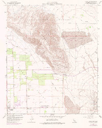
1959 Map of Clark Lake
USGS Topo · Published 1966About this map
Coyote Mountain dominates the central landscape of this 1950s survey, a prominent landmass rising between Clark Valley and the developing irrigation and agricultural tracts of the Borrego Valley. The map documents a pivotal moment in the growth of Borrego Springs, showing the early layout of Di Giorgio Road and Palm Canyon Drive alongside the Borrego Valley Airport and the Borrego School. This period reflects the expansion of the Anza Borrego Desert State Park, whose boundaries wrap around established wells and modern infrastructure like the Borrego Valley Substation and Relay Tower. Historical points of interest, such as the Pegleg Smith Historical Marker near a Gravel Pit, sit alongside older desert routes like Truckhaven and various Jeep Trails that cross the arid Badlands.
Find a feature on this map
23 named features on this map. Tap any name to fly to it.
Don’t see what you’re looking for? This feature index may not catch every label — zoom into the map to look around manually.
Map Details
Editions of this 1959 Clark Lake Map
5 editions found
Other maps of this area

1904 · Indio
USGS Topo · 1:125,000

1931 · Vallecito
USGS Topo · 1:125,000

1939 · Borrego
USGS Topo · 1:62,500

1941 · Clark Lake
USGS Topo · 1:62,500

1942 · Barrel Spring
USGS Topo · 1:62,500

1942 · Agua Dulce
USGS Topo · 1:62,500

1942 · Clark Lake
USGS Topo · 1:62,500

1942 · Borego
USGS Topo · 1:62,500

1943 · Vallecito
USGS Topo · 1:125,000

1944 · Agua Dulce
USGS Topo · 1:62,500