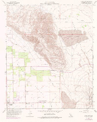
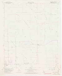
1959 Map of Clark Lake
USGS Topo · Published 1977About this map
Coyote Mountain dominates the northwestern portion of this San Diego County survey, casting a literal and figurative shadow over the developing Clark Valley. The mid-century character of Borrego Springs is visible in its geometric expansion, centered on the distinctive Christmas Circle and surrounded by a burgeoning grid of roads like Di Giorgio Road and Stirrup Road. This era marks a transition from a remote desert outpost to a structured community, evidenced by the presence of the Borrego School and the Borrego Valley Airport. Along the base of the mountains, the Pegleg Smith Historical Marker denotes the regional folklore of the Anza-Borrego Desert State Park, while numerous wells and the ephemeral Clark Lake illustrate the constant search for water in the arid landscape. A network of unimproved ways, including the Rockhouse Truck Trail and various Jeep Trails, provides a look at the early recreational and utility access through the desert floor.
Find a feature on this map
29 named features on this map. Tap any name to fly to it.
Don’t see what you’re looking for? This feature index may not catch every label — zoom into the map to look around manually.
Map Details
Editions of this 1959 Clark Lake Map
5 editions found
Other maps of this area

1904 · Indio
USGS Topo · 1:125,000

1931 · Vallecito
USGS Topo · 1:125,000

1939 · Borrego
USGS Topo · 1:62,500

1941 · Clark Lake
USGS Topo · 1:62,500

1942 · Barrel Spring
USGS Topo · 1:62,500

1942 · Agua Dulce
USGS Topo · 1:62,500

1942 · Clark Lake
USGS Topo · 1:62,500

1942 · Borego
USGS Topo · 1:62,500

1943 · Vallecito
USGS Topo · 1:125,000

1944 · Agua Dulce
USGS Topo · 1:62,500