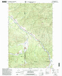
1995 Map of Clarkia
USGS Topo · Published 1997About this map
The St Maries River winds through this Panhandle landscape, where timber and mining operations define the local geography at the end of the 20th century. While the settlement of Clarkia sits near the river's path, the surrounding terrain is marked by industrial activity, including several areas of Dredge Tailings and a Gravel Pit. These features, along with names like Jims Spur, reflect the region's reliance on resource extraction and rail transport. Much of the land is managed as part of the St Joe National Forest, a territory characterized by high summits such as West Elk Peak, East Elk Peak, and Clarkia Peak. The network of creeks, including Emerald Creek and Willow Creek, feeds into the river system, carving out gulches like Two Eightyone Gulch. This survey captures the transition from active extraction to forest management in a region where Shoshone, Benewah, and Latah counties meet.
Find a feature on this map
32 named features on this map. Tap any name to fly to it.
Don’t see what you’re looking for? This feature index may not catch every label — zoom into the map to look around manually.
Map Details
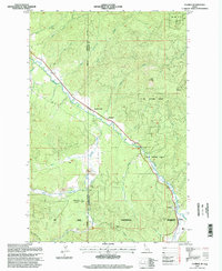
Editions of this 1995 Clarkia Map
2 editions found
Other maps of this area

1955 · Pullman
USGS Topo · 1:250,000

1955 · Spokane
USGS Topo · 1:250,000

1958 · Spokane
USGS Topo · 1:250,000

1958 · Pullman
USGS Topo · 1:250,000

1961 · Fernwood
USGS Topo · 1:62,500

1961 · Bovill
USGS Topo · 1:62,500

1969 · Anthony Peak
USGS Topo · 1:24,000
1969 · Merry Creek
USGS Topo · 1:24,000

1969 · Huckleberry Mtn
USGS Topo · 1:24,000

1981 · St Maries
USGS Topo · 1:100,000