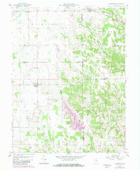
1958 Map of Clarksburg
USGS Topo · Published 1981About this map
Lake Santee dominates the lower central portion of this landscape, its multi-fingered shoreline created by the damming of Bull Fork and several smaller tributaries. This 1980 photorevision captures the man-made lake as a significant alteration to the drainage patterns of the Salt Creek watershed. The map records the meeting point of three counties—Rush, Decatur, and Franklin—highlighting how political boundaries often bisected these rural communities. Small settlements like Clarksburg, Andersonville, and Hamburg anchor the agricultural districts, while the presence of the Treaty Boundary cutting through the eastern hills provides a direct link to early land surveys and historical divisions. Several rural institutions, including Hopewell Ch and Township Sch, alongside family-named burial grounds like Richland Cem, reveal the deep-rooted social and genealogical geography of these townships during the mid-to-late 20th century.
Find a feature on this map
30 named features on this map. Tap any name to fly to it.
Don’t see what you’re looking for? This feature index may not catch every label — zoom into the map to look around manually.
Map Details
Editions of this 1958 Clarksburg Map
4 editions found
Other maps of this area

1946 · Batesville
USGS Topo · 1:24,000

1946 · New Point
USGS Topo · 1:24,000

1953 · Cincinnati
USGS Topo · 1:250,000

1956 · Alpine
USGS Topo · 1:24,000

1956 · Metamora
USGS Topo · 1:24,000

1957 · Cincinnati
USGS Topo · 1:250,000

1958 · Greensburg
USGS Topo · 1:24,000

1958 · Clarksburg
USGS Topo · 1:24,000

1959 · Milroy
USGS Topo · 1:24,000

1959 · Rushville
USGS Topo · 1:24,000