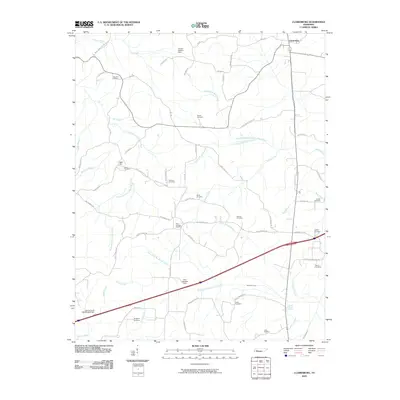
2010 Map of Clarksburg
USGS Topo · Published 2010About this map
Clarksburg sits in the northeast corner of this West Tennessee landscape, where the headwaters of the Rutherford Fork Obion River and Big Sandy River begin to divide the terrain. This rural topography is heavily marked by small family and community burial grounds, such as Palestine Cemetery, Rosser Cemetery, and Hart Cemetery, often situated along ridge lines or near crossroads. The settlement at Bible Hill stands as another focal point amidst a web of local routes including Hart Cemetery Rd and Judge Mcclough Rd.
Find a feature on this map
71 named features on this map. Tap any name to fly to it.
Don’t see what you’re looking for? This feature index may not catch every label — zoom into the map to look around manually.
Map Details
Editions of this 2010 Clarksburg Map
This is the sole edition of this map. No revisions or reprints were ever made.
Other maps of this area

1936 · Clarksburg
USGS Topo · 1:24,000

1936 · Lexington
USGS Topo · 1:24,000

1936 · Yuma
USGS Topo · 1:24,000

1936 · Center Ridge
USGS Topo · 1:24,000

1936 · Buena Vista
USGS Topo · 1:24,000

1936 · Chesterfield
USGS Topo · 1:24,000

1950 · Yuma
USGS Topo · 1:24,000

1950 · Palmer Shelter
USGS Topo · 1:24,000

1950 · Lexington
USGS Topo · 1:24,000
1950 · Chesterfield
USGS Topo · 1:24,000