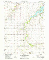
1979 Map of Clarksdale
USGS Topo · Published 1980About this map
The South Fork Sangamon River winds through this central Illinois landscape, carving a wooded corridor through the agricultural townships of Johnson and Greenwood. The northern reach of the map is dominated by the sprawling waters of Lake Taylorville, where recreational developments like the Lake Shore Golf Club and several Picnic Areas mark the lake's 1970s character. Transportation is anchored by the Norfolk and Western railroad corridor, which passes through the small community of Clarksdale in the northwest corner.
Find a feature on this map
28 named features on this map. Tap any name to fly to it.
Don’t see what you’re looking for? This feature index may not catch every label — zoom into the map to look around manually.
Map Details
Editions of this 1979 Clarksdale Map
2 editions found
Other maps of this area

1923 · Taylorville
USGS Topo · 1:62,500

1925 · Taylorville
USGS Topo · 1:62,500

1946 · Nokomis
USGS Topo · 1:62,500

1947 · Pana
USGS Topo · 1:62,500

1949 · Nokomis
USGS Topo · 1:62,500

1949 · Pana
USGS Topo · 1:62,500

1952 · Assumption
USGS Topo · 1:62,500

1958 · Decatur
USGS Topo · 1:250,000

1961 · Decatur
USGS Topo · 1:250,000

1974 · Willeys
USGS Topo · 1:24,000