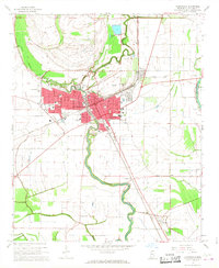
1967 Map of Clarksdale
USGS Topo · Published 1968About this map
Clarksdale serves as the dominant hub of Coahoma County, showing a dense grid of neighborhoods and institutions by the late 1960s. The town's industrial and social fabric is anchored by the Illinois Central railroad and a diverse collection of civic landmarks, including City Hall, Beth Israel Ch, and Higgins High Sch. Beyond the city limits, the landscape transitions into the fertile Delta alluvial plain, where the winding course of the Big Sunflower River and Little Sunflower River dictate the placement of outlying settlements and farms.
Find a feature on this map
53 named features on this map. Tap any name to fly to it.
Don’t see what you’re looking for? This feature index may not catch every label — zoom into the map to look around manually.
Map Details
Editions of this 1967 Clarksdale Map
This is the sole edition of this map. No revisions or reprints were ever made.
Other maps of this area

1908 · Coahoma
USGS Topo · 1:24,000

1908 · Jonestown
USGS Topo · 1:24,000

1910 · Coahoma
USGS Topo · 1:31,680

1910 · Jonestown
USGS Topo · 1:31,680

1932 · Tutwiler
USGS Topo · 1:48,000

1932 · Marks
USGS Topo · 1:48,000

1935 · Clarksdale
USGS Topo · 1:62,500

1935 · Marks
USGS Topo · 1:62,500

1935 · Tutwiler
USGS Topo · 1:62,500

1939 · Farrell
USGS Topo · 1:62,500