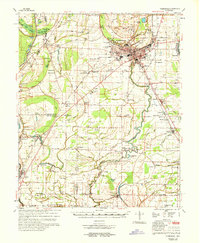
1968 Map of Clarksdale
USGS Topo · Published 1968About this map
The Sunflower River and the Illinois Central Railroad corridor define the landscape of the Mississippi Delta in the late 1960s. At the center of the sheet, Clarksdale serves as a regional hub, featuring the Coahoma High Sch, the County Hospital, and a Radio Tower (WKDL). The map reveals an intricate network of rural life tied to the land, with numerous country churches and cemeteries such as Morning Glory Ch, Beautiful Zion Ch, and the White Stone Cem Ch punctuating the vast agricultural fields. Water management is a primary theme, as seen in the levees, flood control works, and a complex system of bayous and sloughs like Harris Bayou and Overcup Slough. Historical geography is further noted through the preservation of an Indian Mound and local education centers like the Sherard Sch and Africa-Roundaway Sch.
Find a feature on this map
96 named features on this map. Tap any name to fly to it.
Don’t see what you’re looking for? This feature index may not catch every label — zoom into the map to look around manually.
Map Details
Editions of this 1968 Clarksdale Map
This is the sole edition of this map. No revisions or reprints were ever made.
Other maps of this area

1908 · Coahoma
USGS Topo · 1:24,000

1908 · Jonestown
USGS Topo · 1:24,000

1910 · Coahoma
USGS Topo · 1:31,680

1910 · Jonestown
USGS Topo · 1:31,680

1930 · Mellwood
USGS Topo · 1:62,500

1931 · Sumner
USGS Topo · 1:48,000

1931 · Drew
USGS Topo · 1:48,000

1932 · Tutwiler
USGS Topo · 1:48,000

1932 · Marks
USGS Topo · 1:48,000

1935 · Clarksdale
USGS Topo · 1:62,500