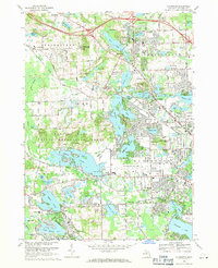
1968 Map of Clarkston
USGS Topo · Published 1971About this map
Deer Lake and the village of Clarkston anchor the northern landscape of this Oakland County survey, where the glacial topography created a dense network of water bodies and marshy lowlands like Huron Swamp. During the late 1960s, the area shows a clear transition from rural estates and institutions—such as Columbiere College—to the burgeoning suburban corridors of Waterford and Drayton Plains. The Grand Trunk Western Railroad and the historic Dixie Hwy facilitate this growth, cutting through the lakes towards the expanding Oakland-Pontiac Airport. Between the developed residential clusters, massive Gravel Pits and public lands like the Pontiac Lake State Recreation Area preserve the area's open space. Genealogists will find numerous family and community landmarks, including Lakeview Cemetery and the Bridge Lake Cem near the northern boundary.
Find a feature on this map
117 named features on this map. Tap any name to fly to it.
Don’t see what you’re looking for? This feature index may not catch every label — zoom into the map to look around manually.
Map Details
Editions of this 1968 Clarkston Map
4 editions found
Other maps of this area

1907 · Pontiac
USGS Topo · 1:62,500

1909 · Milford
USGS Topo · 1:62,500

1920 · Holly
USGS Topo · 1:62,500

1922 · Holly
USGS Topo · 1:62,500

1936 · Wixom
USGS Topo · 1:31,680

1936 · Highland
USGS Topo · 1:31,680

1936 · Clarkston
USGS Topo · 1:31,680

1936 · Walled Lake
USGS Topo · 1:31,680

1936 · Pontiac South
USGS Topo · 1:31,680

1936 · Pontiac North
USGS Topo · 1:31,680
Featured Places
- Waterford Township, MI
- Independence Charter Township, MI
- White Lake Charter Township, MI
- Springfield Charter Township, MI
- Clarkston, MI