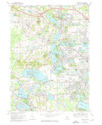
1968 Map of Clarkston
USGS Topo · Published 1974About this map
Glacial lake geography and mid-century suburban expansion define this portion of Oakland County. The Clinton River threads through a dense chain of water bodies, including Deer Lake, Lotus Lake, and Maceday Lake, creating a landscape defined by waterfront living and recreation. The Pontiac Lake State Recreation Area dominates the central west, while the burgeoning aviation hub of the Oakland-Pontiac Airport sits to the south.
Find a feature on this map
108 named features on this map. Tap any name to fly to it.
Don’t see what you’re looking for? This feature index may not catch every label — zoom into the map to look around manually.
Map Details
Editions of this 1968 Clarkston Map
4 editions found
Other maps of this area

1907 · Pontiac
USGS Topo · 1:62,500

1909 · Milford
USGS Topo · 1:62,500

1920 · Holly
USGS Topo · 1:62,500

1922 · Holly
USGS Topo · 1:62,500

1936 · Wixom
USGS Topo · 1:31,680

1936 · Highland
USGS Topo · 1:31,680

1936 · Clarkston
USGS Topo · 1:31,680

1936 · Walled Lake
USGS Topo · 1:31,680

1936 · Pontiac South
USGS Topo · 1:31,680

1936 · Pontiac North
USGS Topo · 1:31,680
Featured Places
- Waterford Township, MI
- Independence Charter Township, MI
- White Lake Charter Township, MI
- Springfield Charter Township, MI
- Clarkston, MI