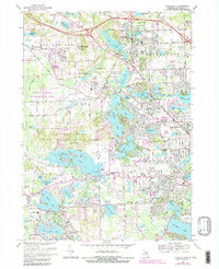
1968 Map of Clarkston
USGS Topo · Published 1984About this map
Deer Lake and the Clinton River serve as the focal points for this late-1960s landscape, illustrating the heavy influence of post-war suburban development around Clarkston and Waterford. The map reveals a dense network of residential subdivisions and community infrastructure, including numerous schools like Schoolcraft Sch and McVittie Sch, alongside long-standing religious landmarks such as St Daniels Chapel and the Church of the Resurrection.
Find a feature on this map
108 named features on this map. Tap any name to fly to it.
Don’t see what you’re looking for? This feature index may not catch every label — zoom into the map to look around manually.
Map Details
Editions of this 1968 Clarkston Map
4 editions found
Other maps of this area

1907 · Pontiac
USGS Topo · 1:62,500

1909 · Milford
USGS Topo · 1:62,500

1920 · Holly
USGS Topo · 1:62,500

1922 · Holly
USGS Topo · 1:62,500

1936 · Wixom
USGS Topo · 1:31,680

1936 · Highland
USGS Topo · 1:31,680

1936 · Clarkston
USGS Topo · 1:31,680

1936 · Walled Lake
USGS Topo · 1:31,680

1936 · Pontiac South
USGS Topo · 1:31,680

1936 · Pontiac North
USGS Topo · 1:31,680
Featured Places
- Waterford Township, MI
- Independence Charter Township, MI
- White Lake Charter Township, MI
- Springfield Charter Township, MI
- Clarkston, MI