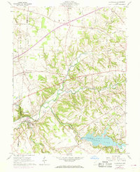
1960 Map of Clarksville
USGS Topo · Published 1968About this map
The Cowan Lake reservoir and the surrounding Cowan State Park dominate the southeastern corner of this landscape, created after the damming of Cowan Creek. The village of Clarksville sits at the junction of Todd Fork and Cowan Creek, serving as a focal point for the Penn Central rail line that cuts through the valley. This 1960s survey illustrates a region of small agricultural settlements and crossroads, including Hickoryville, Oakland, and Vandervorts Corners. Local genealogy is well-supported by several rural landmarks, such as Jonahs Run Ch, Villars Chapel, and the Mt Pleasant Cem overlooking the lake. The terrain is marked by the sharp incision of waterways like Lytle Creek and Jonahs Run into the upland plains, with scattered Gravel Pits indicating local industrial activity.
Find a feature on this map
55 named features on this map. Tap any name to fly to it.
Don’t see what you’re looking for? This feature index may not catch every label — zoom into the map to look around manually.
Map Details
Editions of this 1960 Clarksville Map
Other maps of this area

1907 · Blanchester
USGS Topo · 1:62,500

1913 · Waynesville
USGS Topo · 1:62,500

1914 · Morrow
USGS Topo · 1:62,500

1915 · Waynesville
USGS Topo · 1:62,500

1916 · Morrow
USGS Topo · 1:62,500

1917 · Xenia
USGS Topo · 1:62,500

1947 · Columbus
USGS Topo · 1:250,000

1953 · Cincinnati
USGS Topo · 1:250,000

1955 · New Burlington
USGS Topo · 1:24,000
1955 · Waynesville
USGS Topo · 1:24,000