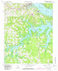
1968 Map of Clarksville South
USGS Topo · Published 1982About this map
The waters of the John H Kerr Reservoir dominate this landscape, branching into numerous inlets such as Blue Creek and Distillery Creek along the Virginia and North Carolina border. The settlement of Clarksville sits at the northern confluence, where the Norfolk Franklin and Danville and Southern railroads intersect. Local history is preserved in several rural landmarks, including the Oakhurst Cem and the Hillcrest Sch, reflecting the community structure before more modern infrastructure like Marks Municipal Airport was developed. To the south, the terrain becomes increasingly defined by small creek branches like Spewmarrow Creek and Cedar Branch, eventually reaching the Island Creek Reservoir. This 1968 survey, updated with 1979 photorevisions, illustrates the transformation of the Roanoke River valley into a major recreation and water management system, anchored by the Occoneechee State Park.
Find a feature on this map
44 named features on this map. Tap any name to fly to it.
Don’t see what you’re looking for? This feature index may not catch every label — zoom into the map to look around manually.
Map Details
Editions of this 1968 Clarksville South Map
3 editions found
Other maps of this area

1941 · Clarksville
USGS Topo · 1:48,000

1943 · Clarksville
USGS Topo · 1:62,500

1953 · Oxford
USGS Topo · 1:62,500

1953 · Greensboro
USGS Topo · 1:250,000

1954 · Greensboro
USGS Topo · 1:250,000

1955 · Boydton
USGS Topo · 1:62,500

1957 · Clarksville
USGS Topo · 1:62,500

1962 · Greensboro
USGS Topo · 1:250,000

1966 · Greensboro
USGS Topo · 1:250,000

1966 · Oxford
USGS Topo · 1:62,500