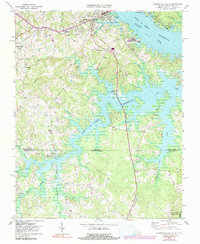
1968 Map of Clarksville South
USGS Topo · Published 1991About this map
The John H Kerr Reservoir dominates this Southside Virginia landscape, its sprawling shoreline defining the border between Virginia and North Carolina. Following the creation of the reservoir, the topography reflects a mix of water-based recreation and traditional rural settlements. To the north, the town of Clarksville serves as a hub, connected by the Southern railroad and the Norfolk Franklin And Danville line. The map captures the transition of the land from agricultural use to public spaces like Occoneechee State Park and the Longwood Public Use Area. Smaller communities such as Buffalo Junction and Soudan persist along the transport corridors, while localized landmarks like Hillcrest Sch, Mt Ararat Ch, and Oakhurst Cem provide essential anchor points for genealogists and local historians tracing family roots in Mecklenburg and Granville counties.
Find a feature on this map
41 named features on this map. Tap any name to fly to it.
Don’t see what you’re looking for? This feature index may not catch every label — zoom into the map to look around manually.
Map Details
Editions of this 1968 Clarksville South Map
3 editions found
Other maps of this area

1941 · Clarksville
USGS Topo · 1:48,000

1943 · Clarksville
USGS Topo · 1:62,500

1953 · Oxford
USGS Topo · 1:62,500

1953 · Greensboro
USGS Topo · 1:250,000

1954 · Greensboro
USGS Topo · 1:250,000

1955 · Boydton
USGS Topo · 1:62,500

1957 · Clarksville
USGS Topo · 1:62,500

1962 · Greensboro
USGS Topo · 1:250,000

1966 · Greensboro
USGS Topo · 1:250,000

1966 · Oxford
USGS Topo · 1:62,500