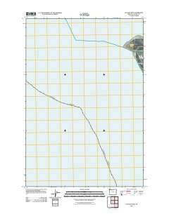
2011 Map of Clatsop Spit
USGS Topo · Published 2011About this map
Clatsop Spit and the mouth of the Columbia River dominate this coastal survey, where the river's massive discharge meets the Pacific Ocean. This specific geographic point has served as a critical navigational waypoint for centuries. The map details the shifting maritime environment, including the Lower Desdemona Shoal and the Entrance Range, which guide vessels through one of the most challenging river bars in the world. On the landward side, Jetty Rd provides the only recorded access point into this dynamic coastal landscape, illustrating the narrow intersection of man-made infrastructure and the powerful natural forces of the Oregon coastline.
Find a feature on this map
6 named features on this map. Tap any name to fly to it.
Don’t see what you’re looking for? This feature index may not catch every label — zoom into the map to look around manually.
Map Details
Editions of this 2011 Clatsop Spit Map
This is the sole edition of this map. No revisions or reprints were ever made.
Other maps of this area

1919 · Astoria
USGS Topo · 1:62,500

1938 · Cape Disappointment
USGS Topo · 1:62,500

1938 · Fort Columbia
USGS Topo · 1:62,500

1939 · Astoria
USGS Topo · 1:62,500

1943 · Fort Columbia
USGS Topo · 1:62,500

1943 · Copalis Beach
USGS Topo · 1:250,000

1949 · Chinook
USGS Topo · 1:24,000

1949 · Gearhart
USGS Topo · 1:24,000
1949 · Cape Disappointment
USGS Topo · 1:24,000

1951 · Copalis Beach
USGS Topo · 1:250,000