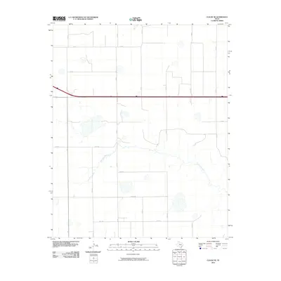
2010 Map of Claude NE
USGS Topo · Published 2010About this map
The Salt Fork Red River meanders across this rural section of Armstrong County, cutting a winding path through a landscape defined by an orderly grid of range roads. This part of the Texas Panhandle is characterized by large agricultural blocks and scattered natural depressions, with a unique system of systematically named thoroughfares including Alpha Rd, Bravo Rd, Charlie Rd, and Delta Rd. These phonetic road names suggest a modern, organized approach to rural addressing in an area where the primary landmarks remain the riverbed and the cardinal-aligned county roads like Co Rd O and Co Rd 4. This survey provides a clear view of the land division and natural drainage patterns before further modern development altered the surface hydrology of the plains.
Find a feature on this map
19 named features on this map. Tap any name to fly to it.
Don’t see what you’re looking for? This feature index may not catch every label — zoom into the map to look around manually.
Map Details
Editions of this 2010 Claude NE Map
This is the sole edition of this map. No revisions or reprints were ever made.
Other maps of this area

1954 · Amarillo
USGS Topo · 1:250,000

1958 · Amarillo
USGS Topo · 1:250,000

1960 · Claude
USGS Topo · 1:62,500

1960 · Groom
USGS Topo · 1:62,500

1966 · Panhandle West
USGS Topo · 1:24,000

1966 · Panhandle East
USGS Topo · 1:24,000

1966 · White Deer SW
USGS Topo · 1:24,000
1983 · Lark
USGS Topo · 1:24,000
1983 · Claude
USGS Topo · 1:24,000
1983 · Claude SW
USGS Topo · 1:24,000