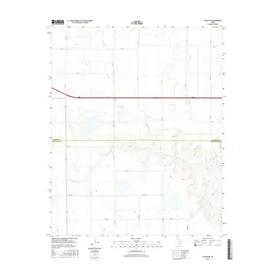
2016 Map of Claude NE
USGS Topo · Published 2016About this map
The Salt Fork Red River meanders through the southern portion of this landscape, carving a distinct drainage pattern across the high plains of the Texas Panhandle. This 2016 survey documents the transition between the flat upland agricultural fields and the broken terrain of the river valley. The map clearly delineates the administrative boundary between Carson County and Armstrong County, illustrating how local governance is superimposed over the natural geography.
Find a feature on this map
20 named features on this map. Tap any name to fly to it.
Don’t see what you’re looking for? This feature index may not catch every label — zoom into the map to look around manually.
Map Details
Editions of this 2016 Claude NE Map
This is the sole edition of this map. No revisions or reprints were ever made.
Other maps of this area

1954 · Amarillo
USGS Topo · 1:250,000

1958 · Amarillo
USGS Topo · 1:250,000

1960 · Claude
USGS Topo · 1:62,500

1960 · Groom
USGS Topo · 1:62,500

1966 · Panhandle West
USGS Topo · 1:24,000

1966 · Panhandle East
USGS Topo · 1:24,000

1966 · White Deer SW
USGS Topo · 1:24,000
1983 · Lark
USGS Topo · 1:24,000
1983 · Claude
USGS Topo · 1:24,000
1983 · Claude SW
USGS Topo · 1:24,000