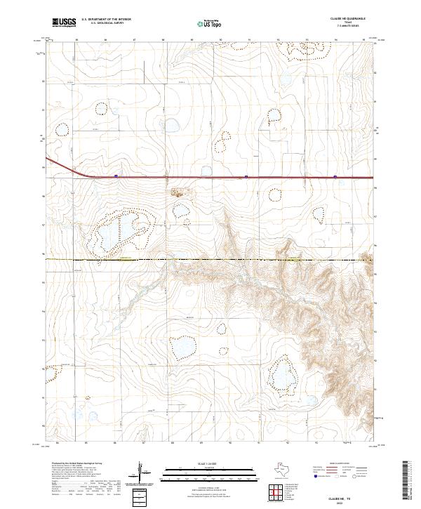
2022 Map of Claude NE
USGS Topo · Published 2022About this map
The Salt Fork Red River carves a deep, intricate drainage pattern across the high plains of the Texas Panhandle, defining the southern half of this landscape. The transition from the flat agricultural tableland to the broken breaks of the river valley is sharp, marked by the abrupt descent of local routes like Co Rd 16 and Co Rd 17. This area sits on the political boundary of Carson and Armstrong counties, where the systematic grid of rural roads is interrupted by the winding geology of the river system. North of the breaks, the terrain remains characterized by expansive agricultural plots and a phonetic naming convention for local connectors, including Alpha Rd, Bravo Rd, Charlie Rd, and Delta Rd, which organize the homesteads and fields north of the river's influence.
Find a feature on this map
20 named features on this map. Tap any name to fly to it.
Don’t see what you’re looking for? This feature index may not catch every label — zoom into the map to look around manually.
Map Details
Editions of this 2022 Claude NE Map
This is the sole edition of this map. No revisions or reprints were ever made.
Other maps of this area

1954 · Amarillo
USGS Topo · 1:250,000

1958 · Amarillo
USGS Topo · 1:250,000

1960 · Claude
USGS Topo · 1:62,500

1960 · Groom
USGS Topo · 1:62,500

1966 · Panhandle West
USGS Topo · 1:24,000

1966 · Panhandle East
USGS Topo · 1:24,000

1966 · White Deer SW
USGS Topo · 1:24,000
1983 · Lark
USGS Topo · 1:24,000
1983 · Claude
USGS Topo · 1:24,000
1983 · Claude SW
USGS Topo · 1:24,000