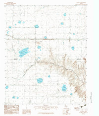
1983 Map of Claude NE
USGS Topo · Published 1984About this map
The Salt Fork Red River carves a deeply dissected channel across this High Plains landscape, creating a stark contrast to the surrounding flat plateau. This 1980s era survey captures a region defined by its physical geography and infrastructure, where the Carson Co and Armstrong Co line intersects with essential transit and utility corridors. To the north, the terrain is marked by an Underground Pipeline and the industrial presence of a Gravel Pit, signaling the local economy's reliance on mineral extraction and resource transport. The lack of concentrated settlements highlights the rural, open character of the Panhandle during this period, with the landscape dominated by the winding river valley and the straight-line paths of regional highways.
Find a feature on this map
7 named features on this map. Tap any name to fly to it.
Don’t see what you’re looking for? This feature index may not catch every label — zoom into the map to look around manually.
Map Details
Editions of this 1983 Claude NE Map
This is the sole edition of this map. No revisions or reprints were ever made.
Other maps of this area

1954 · Amarillo
USGS Topo · 1:250,000

1958 · Amarillo
USGS Topo · 1:250,000

1960 · Claude
USGS Topo · 1:62,500

1960 · Groom
USGS Topo · 1:62,500

1966 · Panhandle West
USGS Topo · 1:24,000

1966 · Panhandle East
USGS Topo · 1:24,000

1966 · White Deer SW
USGS Topo · 1:24,000
1983 · Lark
USGS Topo · 1:24,000
1983 · Claude
USGS Topo · 1:24,000
1983 · Claude SW
USGS Topo · 1:24,000