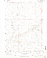
1968 Map of Clay Buttes SW
USGS Topo · Published 1971About this map
Alkali Creek carves a sinuous path through this arid portion of Sweetwater County, defining the drainage patterns across a landscape of high plateaus and dissected ridges. Surveyed in the late 1960s, the map reveals a sparsely settled terrain where transport was primarily limited to unimproved roads and cattle trails. The western edge is marked by Blue Rim Road 6 Mi., a critical access point for the region's ranching and resource activities. Elevated benchmarks like BM X 6963 provide precise vertical control for this high-altitude environment, while the lack of permanent settlements or structures highlights the remote, open-range character of the territory during this period. The survey effectively captures the intersection of Townships 21 and 22 North, illustrating the vast sections of public land that characterize the Wyoming interior.
Find a feature on this map
8 named features on this map. Tap any name to fly to it.
Don’t see what you’re looking for? This feature index may not catch every label — zoom into the map to look around manually.
Map Details
Editions of this 1968 Clay Buttes SW Map
This is the sole edition of this map. No revisions or reprints were ever made.
Other maps of this area

1954 · Rock Springs
USGS Topo · 1:250,000

1958 · Rock Springs
USGS Topo · 1:250,000

1961 · Scott Spring
USGS Topo · 1:24,000

1961 · Pilot Butte
USGS Topo · 1:24,000

1961 · Austin Ranch
USGS Topo · 1:24,000

1962 · Rock Springs
USGS Topo · 1:250,000

1963 · Pittman Well
USGS Topo · 1:24,000
1963 · Chrisman Ranch
USGS Topo · 1:24,000

1968 · Clay Buttes
USGS Topo · 1:24,000

1968 · White Rocks
USGS Topo · 1:24,000