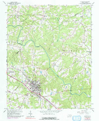
1964 Map of Clayton
USGS Topo · Published 1992About this map
Clayton serves as the primary hub of this landscape, situated along the Southern railroad line as it was surveyed in the early 1960s. The town’s grid is centered around industrial and civic markers such as the Water Tank and Hocutt Memorial Ch, while residential expansion is noted in purple revisions from the 1970s. The surrounding Johnston County countryside is defined by the winding course of the Neuse River, which separates the township from the community of Archers Lodge and the agricultural lands of Wilders.
Find a feature on this map
46 named features on this map. Tap any name to fly to it.
Don’t see what you’re looking for? This feature index may not catch every label — zoom into the map to look around manually.
Map Details
Editions of this 1964 Clayton Map
3 editions found
Other maps of this area

1943 · Raleigh
USGS Topo · 1:62,500

1951 · Raleigh
USGS Topo · 1:62,500

1953 · Raleigh
USGS Topo · 1:250,000

1954 · Raleigh
USGS Topo · 1:250,000

1964 · Garner
USGS Topo · 1:24,000

1964 · Flowers
USGS Topo · 1:24,000

1964 · Selma
USGS Topo · 1:62,500

1964 · Clayton
USGS Topo · 1:24,000

1964 · Edmondson
USGS Topo · 1:24,000

1964 · Garner
USGS Topo · 1:62,500