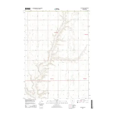
2015 Map of Clayton NE
USGS Topo · Published 2015About this map
Huber Cem sits alone in the southeastern quarter of this section of Hutchinson County, a quiet marker of the rural heritage of the Dakotas. The landscape is defined by the incision of Wolf Cr and Elm Cr into the prairie, creating a series of draws and ridges that break the regularity of the surrounding agricultural land. Unlike the flat plains often associated with the region, the terrain here is deeply carved by these waterways, influencing the placement of the section-line roads. The vast network of graded roads, including 273rd St and 431st Ave, follows the Public Land Survey System grid, providing access to the distributed farmsteads and fields that form the economic backbone of this rural community.
Find a feature on this map
22 named features on this map. Tap any name to fly to it.
Don’t see what you’re looking for? This feature index may not catch every label — zoom into the map to look around manually.
Map Details
Editions of this 2015 Clayton NE Map
This is the sole edition of this map. No revisions or reprints were ever made.
Other maps of this area

1898 · Olivet
USGS Topo · 1:125,000

1898 · Parker
USGS Topo · 1:125,000

1899 · Alexandria
USGS Topo · 1:125,000

1955 · Sioux Falls
USGS Topo · 1:250,000

1957 · Tschetter Colony
USGS Topo · 1:24,000

1957 · Clayton
USGS Topo · 1:24,000

1957 · Wolf Creek
USGS Topo · 1:24,000

1958 · Sioux Falls
USGS Topo · 1:250,000

1964 · Bridgewater East
USGS Topo · 1:24,000

1970 · Clayton NE
USGS Topo · 1:24,000
Featured Places
- Pleasant Township, SD
- Taylor Township, SD
- Grandview Township, SD
- Silver Lake Township, SD
- Wolf Creek Township, SD