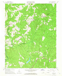
1964 Map of Clayville
USGS Topo · Published 1966About this map
The Appomattox River winds through this mid-1960s landscape, serving as a natural boundary between Chesterfield, Powhatan, and Amelia counties. The region is characterized by small rural settlements and a network of creeks like Swift Creek and Skinquarter Creek. The Southern railroad line acts as a central artery for the area, connecting several small communities such as Moseley, Dorset, and Clayville. These towns are anchored by essential local institutions, including the Grange Hall Sch and a series of rural houses of worship such as Skinquarter Ch and Graceland Ch. The presence of a Quarry near Genito and a Gravel Pit indicates the local extractive industries of the period. Unusual for many topographic sheets, this survey also includes checked field lines and fence boundaries, providing a rare level of detail for those researching historical land use and property divisions.
Find a feature on this map
37 named features on this map. Tap any name to fly to it.
Don’t see what you’re looking for? This feature index may not catch every label — zoom into the map to look around manually.
Map Details
Editions of this 1964 Clayville Map
3 editions found
Other maps of this area

1890 · Goochland
USGS Topo · 1:125,000

1892 · Goochland
USGS Topo · 1:125,000

1897 · Amelia
USGS Topo · 1:125,000

1943 · Fine Creek Mills
USGS Topo · 1:31,680

1943 · Powhatan
USGS Topo · 1:31,680

1943 · Amelia
USGS Topo · 1:31,680

1943 · Goodes Bridge
USGS Topo · 1:31,680

1943 · Hallsboro
USGS Topo · 1:31,680

1943 · Clayville
USGS Topo · 1:24,000

1943 · Midlothian
USGS Topo · 1:24,000