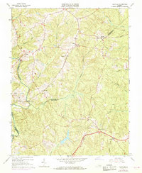
1964 Map of Clayville
USGS Topo · Published 1969About this map
The Appomattox River forms the western boundary of this Piedmont landscape, where the borders of Chesterfield, Powhatan, and Amelia counties converge. The Southern railway line serves as a central corridor for rural commerce, linking settlements like Moseley, Dorset, and Clayville. This mid-century survey illustrates a period when small community centers like Mattoax and Genito remained distinct hubs, often anchored by local industry such as the Rapids Quarry or established gathering places like Antioch Church.
Find a feature on this map
35 named features on this map. Tap any name to fly to it.
Don’t see what you’re looking for? This feature index may not catch every label — zoom into the map to look around manually.
Map Details
Editions of this 1964 Clayville Map
3 editions found
Other maps of this area

1890 · Goochland
USGS Topo · 1:125,000

1892 · Goochland
USGS Topo · 1:125,000

1897 · Amelia
USGS Topo · 1:125,000

1943 · Fine Creek Mills
USGS Topo · 1:31,680

1943 · Powhatan
USGS Topo · 1:31,680

1943 · Amelia
USGS Topo · 1:31,680

1943 · Goodes Bridge
USGS Topo · 1:31,680

1943 · Hallsboro
USGS Topo · 1:31,680

1943 · Clayville
USGS Topo · 1:24,000

1943 · Midlothian
USGS Topo · 1:24,000